


Next: EVALUATION
Up: OORF: AN OBJECT-ORIENTED ROUTE
Previous: Significance of the Model's
This section presents the problem solving method in the proposed
approach. It consists of four main steps. Below is the algorithm.
- Step 1. Get the type of the road on which source
node (
 )
is located by invoking appropriate method
)
is located by invoking appropriate method
in source node.
- if this type matches with the major road
- then goto step 2
- else
- Find the index number of the
neighbourhood in which is
located by invoking appropriate
method in source node. ( we call
this neighbourhood as source
neighbourhood )
- Retrieve the road network in the
source neighbourhood.
- Step 2. Get the type of the road on which destination
node (
 ) is located by invoking appropriate
method in destination node.
) is located by invoking appropriate
method in destination node.
- if this type matches with the major road
- then goto step 3
- else
- Find the index number of the
neighbourhood in which is
located by invoking appropriate
method in the destination
node. (we call this neighbourhood
as destination
neighbourhood)
- Retrieve the road network in the
destination neighbourhood.
- Step 3.
- if Both, the source and the destination nodes, are on
minor roads.
- then
- Find the name of the the container geo-object
containing source neighbourhood and destination
neighbourhood.
- Retrieve the major road network in the container
geo-object.
- goto step 4.
- else if Both, the source and the
destination nodes, are on major roads.
- then
- Find the name of the the container geo-object
containing and .
- Retrieve the major road network in the container
geo-object.
- goto step 4.
- else if One (S or D) of the source or
destination nodes is on the minor road and the other
is on major road.
- then
- Find the name of the container geo-object containing
neighbourhood that contains the node which is
on the minor road, and the other node that is on
major road.
- Retrieve the major road network in the container
geo-object
- Step 4. Run the shortest path algorithm such as
Dijkstra's algorithm, with this augmented road network.
Now, let us do analysis of the complexity of the algorithm. When all the
network is in the hard disk then road network in the source and the
destination neighbourhood is transferred into the main memory in a
constant time. (1) and (2) in step 1 and 2 can be done in a constant
of time because each node has an index number of the neighbourhood
containing it. (1) in step 3 is also done in a constant of time because
each neighbourhood or container geo-object also knows the name of it's
container geo-object. Retrieving road network in neighbourhood and
container geo-object is also done in a constant of time as we have
designed our road network in such a way that it contains the road
network at each level as a group of links. Main computation is done in
step 4. Since the number of nodes and arcs (links) have been
substantially reduced, it will run much faster.
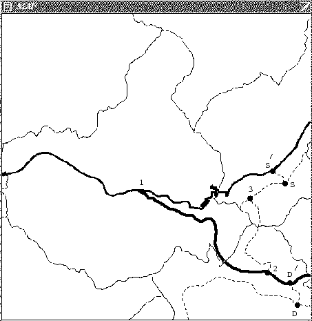
Now, we will present a complete example of problem solving in
our proposed approach. Suppose a user would like to go from source to
destination shown in Figure 5.
The road network (thin dotted lines
are minor roads and thin solid lines are boundaries of container
geo-objects) is retrieved in neighbourhood containing and and
major road network is retrieved in the geo-object containing source and
destination neighbourhood. And then this augmented road network with
knowledge such as, peak hours, road construction, road facilities,
etc., in the source and destination neighbourhood and the
geo-object containing these neighbourhood is used to search the
shortest path between and i.e.
 .
.
Figure 5:
A Route Finding Example
 |
Next: EVALUATION
Up: OORF: AN OBJECT-ORIENTED ROUTE
Previous: Significance of the Model's
M.Abaidullah ANWAR
1999-11-25